

The Ecuador Amazon Region continues to remind me how much there is to discover in the country I call home.
Many people associate Ecuador with the Galapagos Islands, Pacific beaches, or mountain cities such as Quito and Cuenca. However, another extraordinary landscape lies east of the Andes: a region of forests, rivers, wetlands, towns, and Indigenous territories.
The Ecuador Amazon Region is made up of six provinces: Sucumbios, Orellana, Napo, Pastaza, Morona Santiago, and Zamora Chinchipe. Each has its own communities, landscapes, and local history.
And here is a fact that surprised me while studying Ecuadorian geography: Pastaza is Ecuador’s largest province by area.
Not Manabi. Not Guayas. Not Pichincha.
The answer is in the Ecuador Amazon Region. 🌿
Where Is the Ecuador Amazon Region?
The Ecuador Amazon Region is located east of the Andes. Its landscapes extend from the eastern mountain slopes toward lower rainforest areas and form part of the wider Amazon Basin.
Nevertheless, it should not be imagined as one uniform stretch of lowland jungle. Mountain environments, forested foothills, rivers, and tropical forests are found within its provinces.
For example, Papallacta, known for its hot springs and mountain scenery, is located in Napo. Its inclusion in Ecuador’s official information about the region illustrates how varied these landscapes can be.
This variety is important when looking at a map. Provincial boundaries are administrative divisions, while ecosystems change with elevation, water, and other environmental conditions.
Consequently, knowing that a place belongs to the Ecuador Amazon Region does not mean its scenery will look exactly like every other part of the region.
The Six Provinces of the Ecuador Amazon Region
Learning the six provinces and their capitals makes Ecuadorian geography easier to understand. It also helps place news stories, cultural discussions, and environmental issues on the map.
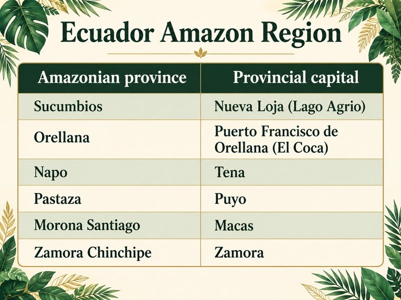
These provinces make up the Ecuador Amazon Region, but each represents a distinct part of it. Their capitals are important centers of government, commerce, and everyday community life.
The difference between a province and its capital is worth remembering.
Pastaza is the province, while Puyo is its capital. Similarly, Napo is the province, while Tena is the capital.
Once those pairs are remembered, the map starts to feel considerably less intimidating.
Pastaza: Ecuador’s Largest Province by Area
Pastaza is Ecuador’s largest province by area, covering approximately 29,600 square kilometers, or about 11,400 square miles. Its provincial capital is Puyo.
That distinction refers to land area, rather than population.
A province can occupy a large part of the map without having the greatest number of residents. In fact, Ecuador’s 2022 census identifies Pastaza among the country’s least populated provinces, while Guayas has the largest population.
Therefore, if a geography question asks for Ecuador’s “largest province,” it helps to check whether it means area or population.
Pastaza lies in the central part of the Ecuador Amazon Region. It borders Peru to the east, along with Napo, Orellana, Morona Santiago, and Tungurahua around its other boundaries.
For me, learning this changes how I look at Ecuador. The provinces that receive the most attention are not necessarily the ones that occupy the most space.
Yasuni and Wildlife in the Ecuador Amazon Region
One of the best-known protected areas in the Ecuador Amazon Region is Yasuni National Park, which extends across parts of Orellana and Pastaza.
The park is recognized for its exceptional biodiversity. A remarkable variety of mammals, birds, amphibians, fish, and insects is supported by its habitats. ecuador.travel
However, biodiversity means more than a long list of animals.
A forest is shaped by relationships between plants, wildlife, water, and soil. Different habitats provide different conditions. Consequently, a riverbank, a flooded forest, and an upland forest should not be treated as interchangeable environments.
Learning about the Ecuador Amazon Region therefore involves looking beyond the familiar image of a thick green canopy. Its rivers and wetlands are also essential parts of the landscape.
Freshwater dolphins offer a particularly memorable example of the wildlife associated with these waterways.
Pink River Dolphins in the Ecuador Amazon Region
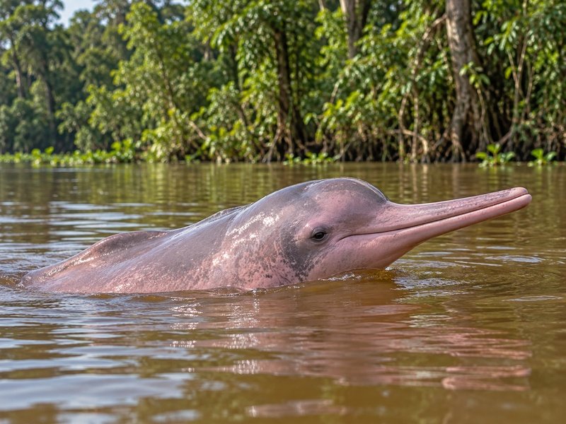
Yes—pink river dolphins live in the Ecuador Amazon Region.
The Amazon river dolphin, scientifically known as Inia geoffrensis, is one of the freshwater dolphin species found in Ecuador. Another is the tucuxi, Sotalia fluviatilis.
In research reported by Ecuador’s National Institute of Biodiversity in July 2026, pink river dolphins were confirmed in 37 rivers in the country.
So, a pink dolphin is not automatically a fantasy animal.
Nevertheless, the dolphin in my picture was included with a little creative license. It should not be taken as photographic evidence of a wildlife encounter—or proof that El Gringo drank anything unusual. 😂🐬
There is also a serious side to their story. Research has documented threats to Ecuador’s river dolphins, including deliberate hunting and accidental capture in fishing nets.
Their presence makes the Ecuador Amazon Region fascinating, but their survival depends on protecting the waterways where they live.
Indigenous Peoples and Cultures of the Ecuador Amazon Region
The Ecuador Amazon Region is home to Indigenous peoples with distinct languages, histories, institutions, and relationships with their territories.
It is a lived landscape where communities maintain traditions while participating in contemporary society.
Ecuador’s official tourism information emphasizes that Indigenous peoples are defenders of collective rights and holders of knowledge that continues to be applied today.
This matters when cultural practices are discussed.
A tradition found in one community should not automatically be attributed to every Indigenous person in the Ecuador Amazon Region. Likewise, the meaning of a ceremony is best understood through the people who maintain it.
For someone like me, learning about Ecuador means learning about people as well as places. Geography can show us where a community lives, but it cannot explain an entire culture by itself.
Ayahuasca and Traditional Ceremonies
Ayahuasca is a psychoactive plant brew used for ceremonial and traditional healing purposes by some Indigenous peoples. Its use has been documented in Ecuador and other countries within the wider Amazon Basin.
However, practices and interpretations vary between communities and traditions. Ayahuasca should not be presented as a universal practice throughout the Ecuador Amazon Region.
The word is also used for the vine Banisteriopsis caapi, which is central to many preparations. The beverage is commonly prepared with that vine and other plant ingredients, although its composition varies.
Ayahuasca can produce pronounced changes in perception, emotion, and the experience of consciousness. It is therefore quite different from an ordinary herbal tea.
Nevertheless, its cultural significance extends beyond those effects. Within particular traditions, its use is connected to systems of knowledge, spiritual interpretation, and healing.
Research on traditional medicine highlights the importance of understanding those wider practices instead of separating the brew from its cultural context.
That is what interests me while studying: a familiar name can open the door to a much more complex subject.
And, for the record, including a pink dolphin in a picture is still not a confession. 😂
Why the Ecuador Amazon Region Matters
The Ecuador Amazon Region adds another dimension to a country already known for its coast, mountains, and islands.
Its six provinces bring together extensive forest landscapes, freshwater ecosystems, protected areas, towns, and living cultures.
Furthermore, environmental protection and community life are closely connected. Decisions about land, rivers, and natural resources affect both wildlife and the people whose homes and livelihoods depend on those places.
Even learning the names of the six provinces can make a difference. Suddenly, a report about Orellana or a discussion about Pastaza has a location on the map.
That is what I enjoy about studying Ecuador.
Each fact makes the country I call home a little more familiar. Sometimes the lesson is a province name. Sometimes it is a national park. And sometimes it is discovering that pink dolphins really do live here.
Six provinces. Pastaza is the largest by area. Pink river dolphins are real.
A few more facts to remember—and another reason to keep learning about the Ecuador Amazon Region. 🌎🌿
If you want to learn more about Ecuador’s history, click here